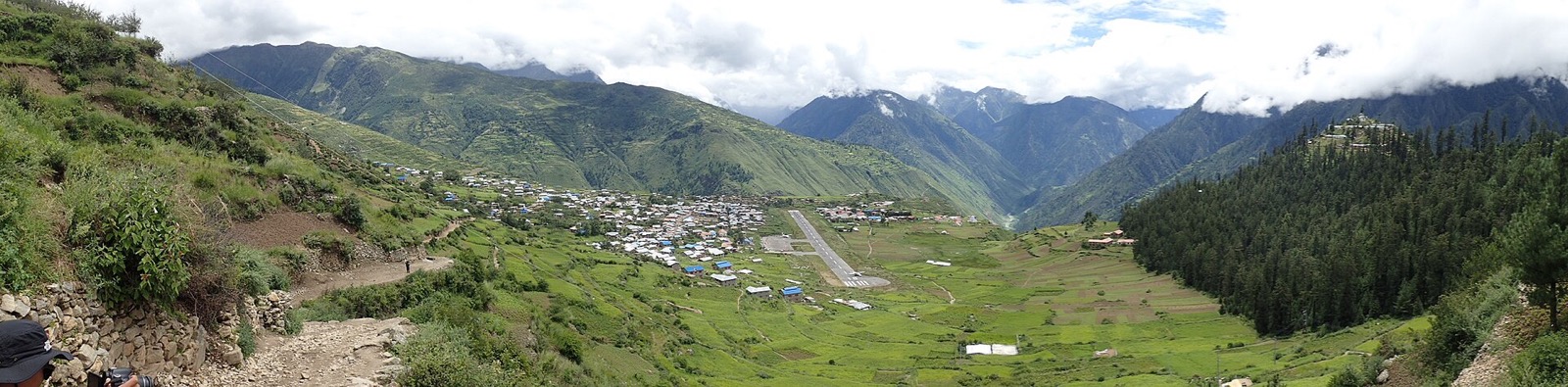
Humla is the far corner of Karnali Province, reached by air or on foot. The trails north from Simikot lead to the Tibet border at Hilsa, the Limi Valley and the pilgrim route to Mount Kailash1,2. This page covers the district as a whole; the other far-west districts are in the districts hub, and the Limi walk has its own Limi Valley trek page.
Where it is
Humla lies in the far west of Nepal, on the border between Nepal and China, and is used as the starting point for trekking and mountaineering1. It is a district of Karnali Province with Simikot as its administrative headquarters1. At 5,655 km2 it is the second-largest district in Nepal by area1. Namkha Rural Municipality, inside Humla, is the largest rural municipality in Nepal by area1.
The district is divided into 7 rural municipalities and has no urban municipality1. The 2021 census counted 55,394 people, and the entire population lives in rural areas1. In 2011 the district had 50,858 people1.
Humla is a historic part of the Tibetan Buddhist religious tradition, with eleven small villages of Tibetan origin1. The Limi Valley is inhabited by Buddhist communities1. In 2021 Hinduism was the religion of 87.45% of the population and Buddhism of 12.15%1. Wild yaks, once thought regionally extinct in Nepal, were rediscovered in Humla in 20141.
Getting there
By air
In October 2026 Humla could be reached only by air or on foot, and road transport was still under construction1. Because road access is weak, Simikot Airport carries travel for the whole district2. It stands at 9,246 ft (2,818 m) above sea level2. The runway has recently been improved and extended, with more infrastructure being built2.
In October 2026 the airport listing showed Tara Air and Sita Air flying from Nepalgunj, and Summit Air and Nepal Airlines flying from Nepalgunj and Birendranagar2. Operators and routes are covered in flights to Simikot.
On 23 June 2011 a Tara Air Dornier 228 on a cargo flight from Nepalgunj was substantially damaged in a heavy landing and runway excursion at Simikot2.
By road and on foot
In October 2026 a motorable road from Hilsa to Simikot was in the process of being built1. Pilgrims and trekkers bound for Lake Manasarovar and Mount Kailash in China’s Tibet Autonomous Region fly into Simikot and proceed to the international border at Hilsa on foot2.
The route to Hilsa and Kailash
In recent years Humla has grown in significance as a preferred route for the Kailash pilgrimage1. The ancient foot trail from Simikot to Hilsa runs along the mountain slopes on the left side of the Humla Karnali river1. The walk takes 4 to 5 days, with overnight stops at a few villages, and crosses the 4,530 m Nara La pass1.
| Option | Time | Note |
|---|---|---|
| Walk Simikot to Hilsa | 4 to 5 days | Crosses Nara La, 4,530 m1 |
| Helicopter Simikot to Hilsa | about 20 minutes | Offered by travel companies1 |
A longer alternative leaves the main trail at the confluence of the Humla Karnali and Salli Khola rivers and reaches Hilsa through the Nyalu La pass and the Limi valley1. A detour from that route to the Lapcha La pass, close to the border with China, gives open views of Lake Manasarovar and Mount Kailash on a clear day1. The Nepal section of the Great Himalaya Trail ends in Humla at Hilsa, on the border with Tibet1.
The Kailash approach has more detail on the Humla to Kailash page.
Permits
Restricted-area trekking in Nepal needs a trekking permit from the Department of Immigration, Kalikasthan, Kathmandu4. Foreign trekkers going to certain restricted areas must hold one by law, and the Department of Immigration issues these permits only through registered trekking agencies5.
In October 2026 the Department of Immigration’s fee table listed Humla at USD 50 per person per week, plus USD 10 per day beyond one week3. The Nepal Tourism Board listed the same amounts4. The permit covers parts of three rural municipalities3:
| Rural municipality | Wards covered | Seen |
|---|---|---|
| Simikot | 1, 6 and 7 | October 20263 |
| Namkha | 1 to 6 | October 20263 |
| Changkheli | 3 to 5 | October 20263 |
For comparison, in October 2026 the same table listed Mugu at USD 100 per person per week and Bajhang and Darchula at USD 90 per week, each with USD 15 per day beyond the first week3. Rules for every area are collected in restricted-area permits.
What to see
The Simikot to Hilsa trail, the Limi Valley and the passes of Nara La and Lapcha La are the walking routes in the district1. Humla has eleven small villages of Tibetan origin, and the Nyin Community and the Limi Valley are inhabited by Buddhist communities1.
Simikot is the district headquarters and has the district’s airport1,2. In Sirkigad Rural Municipality stands the Sarki Temple, dedicated to the ancestral deity of the Sarki community1.
Safety
The passes are high: Nara La is 4,530 m1, and Simikot itself is at 2,818 m2. In October 2026 Humla could be reached only by air or on foot1.
Read next
Limi Valley trek: route, days, season, permits and cost
Limi Valley trek in Humla: a day-by-day stage table from Simikot, the passes, the best months, the Humla permit fee and what an operator charges.
Getting thereFlights to Simikot: Nepalgunj and Surkhet schedules for Humla
Flights to Simikot, Humla: the Nepal Airlines October 2026 timetable from Nepalgunj and Surkhet, other operators, airport facts and the way on to Hilsa.
District guidesMugu: Rara Lake, Talcha airport and the roads in
Mugu district guide for Rara Lake: Gamgadhi, Talcha airport, getting in from Surkhet and Jumla, the best months, the permit and where to stay.
Questions travellers ask
What is Humla District famous for?
Humla is the starting point for trekking and mountaineering and for the trekking route to Tibet from Simikot1. Simikot Airport is the main tourist gateway on the Nepali side to Mount Kailash and Lake Manasarovar2.
How do I get to Humla, Nepal?
In October 2026 Humla could be reached only by air or on foot1. Simikot Airport serves the district, and Tara Air, Sita Air, Summit Air and Nepal Airlines are listed as flying there from Nepalgunj2; Summit Air and Nepal Airlines also fly from Birendranagar2.
Sources
- Humla District · Wikipedia · en.wikipedia.org · checked 19 October 2026
- Simikot Airport · Wikipedia · en.wikipedia.org · checked 19 October 2026
- Trekking Route and Permit Fee (Department of Immigration) · Department of Immigration · immigration.gov.np · checked 19 October 2026
- Trekking Permit in Nepal (Nepal Tourism Board) · Nepal Tourism Board · ntb.gov.np · checked 19 October 2026
- Trekking Permit (Department of Immigration) · Department of Immigration · immigration.gov.np · checked 19 October 2026
Image credits (1)
- Rvmedia / Wikimedia Commons · CC BY-SA 4.0 · source

Fees, fares and road conditions change: each note shows the date it was checked. How we check facts · Report an error.