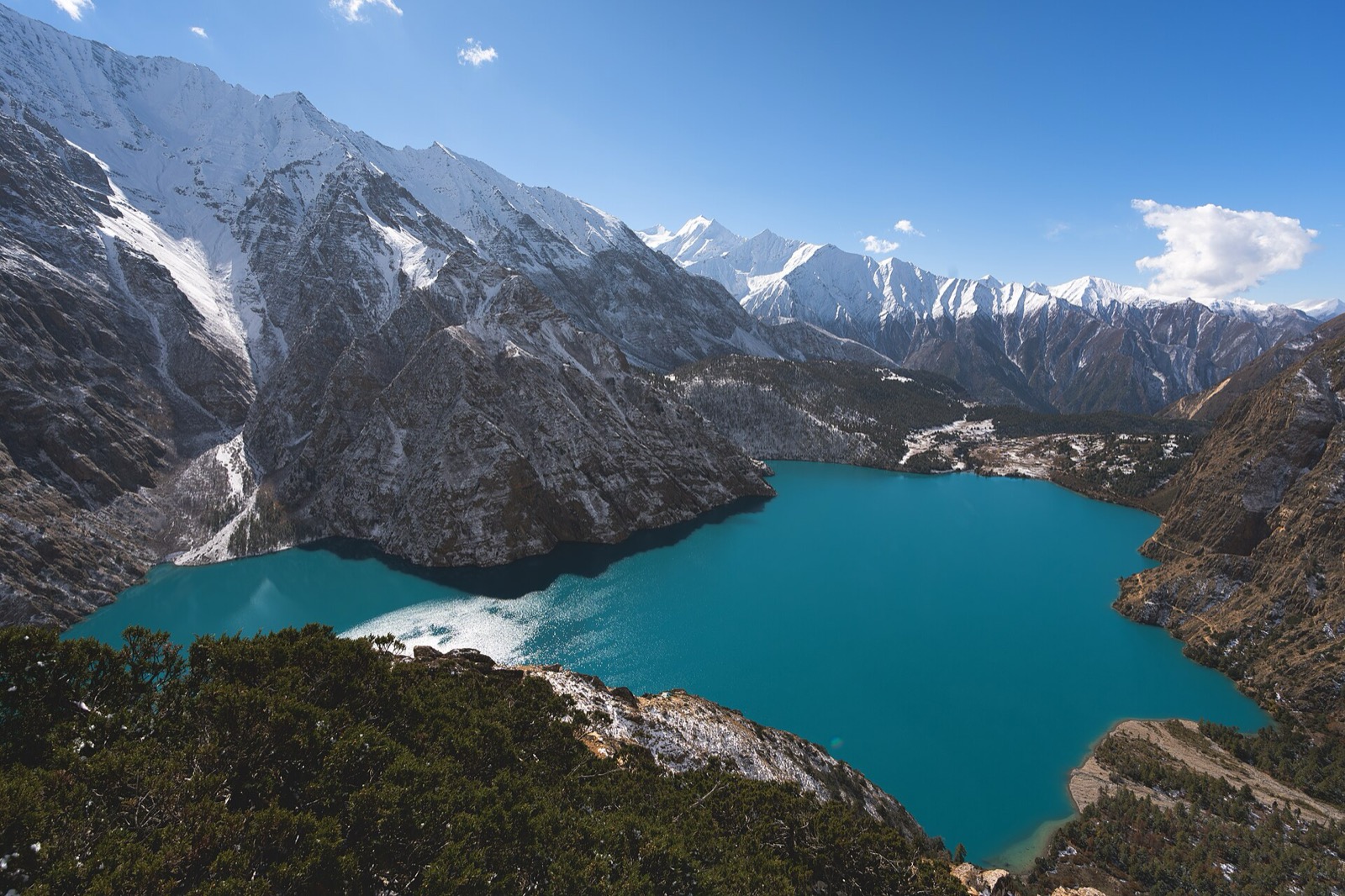
Dolpa is the largest district in Nepal1. Juphal airport, the road from Rukum and Jajarkot, and Shey Phoksundo National Park, which protects a large part of the district, are covered below2,1. This page covers the district; the neighbouring ones are in the districts hub, and the walks have their own pages, starting with the Phoksundo Lake trek.
Where it is
Dolpa is the largest district of Nepal, covering 5.36% of the total landmass of the country1. Dunai is the district headquarters, and the district covers 7,889 km21. It lies between latitudes 28°43’N and 29°43’N and longitudes 82°23’E and 83°41’E1.
The district borders Tibet on the north and northeast, and Jumla and Mugu on the west1. Elevation ranges from 1,525 m to 7,625 m1. Wikipedia’s text also gives the range as a little over 1,500 m at Tribeni to 7,381 m at the peak of Churen Himal1. It calls the district a labyrinth of often wide glacial valleys and ridges, and puts 70.2% of its area in the Trans-Himalayan zone1. Kanjiroba at 6,221 m, Mukot at 6,638 m and Putha Hiunchuli at 7,246 m are among its renowned peaks1.
The 2021 census counted 42,774 people1. Wikipedia’s 2021 breakdown has Chhetri at 47.4%, Magar at 12.1% and Dolpo at 12.0%1. Agriculture is the major occupation, at 79.5%1. Khas people make up 68% of the population and Hill Janjatis 31%1. The district has 8 municipalities, 2 urban and 6 rural1. Its cultural traditions are basically linked with Tibetan culture1.
Getting there
By air
Dolpa (Juphal) Airport is the gateway to Shey Phoksundo National Park, where Phoksundo Lake is the major attraction, and it also connects to the Upper Dolpa trek2. The airport is a three-hour walk from the district headquarters, Dunai2. It stands at 2,503 m2, and has an asphalt runway2. It began operating in 19752. The Civil Aviation Authority’s airport profile listed operating hours of 06:30 to 12:15 local time from 16 November to 15 February, and 06:00 to 12:15 from 16 February to 15 November2. Dolpa Travel puts the Nepalgunj to Juphal flight at 35 to 45 minutes, usually in the morning, after a Kathmandu to Nepalgunj flight of about one hour7. Flights are weather-dependent and may be delayed or cancelled7.
The Civil Aviation Authority’s 2020 airport profile listed Tara Air, Sita Air, Nepal Airlines and Summit Air as the scheduled airlines, with connections to Nepalgunj and Surkhet2. The aircraft types are the DHC6, L410 and Y12, flying under visual flight rules2. Juphal is a village that is now part of Thuli Bheri Municipality3. See flights to Juphal for the operators.
In July 2016 flights to and from Jufal airport were affected for a week by bad weather, flights from Nepalgunj stopped because of incessant rainfall, and passengers were stranded by the closure of the airport4.
By road
In November 2012 Dolpa, despite being the largest district in area, had only 1 vehicle and no road links to other districts1. A 118 km road linking Dunai with Rukum and Jajarkot was completed in 2018, which connected the district with the national road network1.
Dunai
GLT UAE, a travel guide, places Dunai at 2,000 m, on the bank of the Thulo Bheri River, and gives it about 350 households8. It names Dunai the biggest town of Dolpo and the base for both Upper and Lower Dolpo8. Dolpa Travel’s routes run Nepalgunj to Juphal by air, then a one-hour jeep ride from Juphal to Dunai, then 2 to 3 days on foot from Dunai to Phoksundo Lake7. Its road alternative runs from Nepalgunj to Surkhet, then Jajarkot and Rukum, then a drive to Tripurakot or Dunai and a trek of 2 to 4 days to the lake7.
GLT UAE writes that the clouds, sky and mountains are worshipped at Dunai, and that visitors can see both Tibetan Buddhist and Bon practices8. Staple crops there include millet, pumpkin, potatoes, sweet corn and chilies8. It also reports that a track along the Tarpare cliff, on the Jajarkot-Dolpa road section, connects Dunai to the national road network8.
Shey Phoksundo National Park
A large portion of the district is protected by Shey Phoksundo National Park1. The park’s name is derived from the 12th-century Shey Monastery and the deepest lake in Nepal, Phoksundo Lake, both of which lie in the district1. The park protects endangered animals including the snow leopard, musk deer and Tibetan wolf1. GLT UAE, a travel guide, adds blue sheep and Himalayan black bears8.
Phoksundo Lake is known for its turquoise waters and is a sacred site for local people, with deep spiritual importance and visits from pilgrims and spiritual seekers, as Dolpa Travel’s page puts it7. By local legend the lake was created when a demoness flooded a village7. The Suligad waterfall at the outlet is about 167 m, one of the highest in Nepal on the same operator’s account7. The lake features in local folklore, songs and rituals7. Dunai is the only gateway to Dolpo, per GLT UAE8.
Permits
Dolpa is split into a Lower and an Upper area for permits. In October 2026 the Department of Immigration’s fee table listed these5:
| Area | Permit | Beyond the first period | Seen |
|---|---|---|---|
| Lower Dolpa | USD 20 per person per week | USD 5 per day beyond 1 week | October 20265 |
| Upper Dolpa | USD 500 per person for the first 10 days | USD 50 per person per day beyond 10 days | October 20265 |
Lower Dolpa covers Thulibheri and Tripurasundari municipalities (wards 1 to 11), Dolpo Buddha RM (wards 1 to 3), Shey Phoksundo RM (wards 8 and 9), Jagdulla RM (wards 1 to 6), Mudkechula RM (wards 1 to 9) and Kaike RM (wards 1 to 7)5. Upper Dolpa covers Dolpo Buddha RM (wards 4 to 6), Shey Phoksundo RM (wards 1 to 7) and Charka Tangsong RM (wards 1 to 6)5. For Upper Dolpa, if the royalty paid for a mountain expedition is less than the trekking permit fee, the difference must be paid separately5.
Shey Phoksundo National Park also charges an entry fee. In October 2026 the Nepal Tourism Board’s park entry-fee table listed the following per person per entry, with children under 10 free6:
| Visitor | Entry fee | Seen |
|---|---|---|
| Nepali | NPR 100 | October 20266 |
| SAARC national | NPR 1,500 | October 20266 |
| Foreigner | NPR 3,000 | October 20266 |
Rules for every permit area are collected in restricted-area permits, and park charges in national park fees.
Where to go next
Walking routes: Lower Dolpo trek, Upper Dolpo trek and the Phoksundo Lake trek. Jumla and Mugu, on the district’s western border1, are covered in Jumla and Mugu. GLT UAE calls the Dunai to Phoksundo walk one of the region’s popular treks and says those wanting a longer trip often go on to Rara Lake in Jumla8.
Read next
Flights to Juphal: Nepalgunj to Dolpa for Phoksundo and Dolpo
Flights to Juphal airport in Dolpa: the Nepal Airlines October 2026 timetable from Nepalgunj, operators, airport facts, the walk to Dunai and weather closures.
TreksShey Phoksundo Lake trek: route, days, permits and costs
Shey Phoksundo Lake trek in Dolpa: the Juphal to Ringmo stages, the lake's altitude, the best month, the Lower Dolpa permit, park fee and operator prices.
TreksUpper Dolpo trek: route, days, passes, permit fee and cost
Upper Dolpo trek guide: a 27-day operator itinerary from Juphal, the high passes, the season, the USD 500 permit and park fees, and group prices.
Questions travellers ask
What is Dolpa famous for?
Dolpa is the largest district in Nepal1 and holds Shey Phoksundo National Park, with Phoksundo Lake, the deepest lake in Nepal1. Its culture is linked with Tibetan culture1.
How do I reach Dunai in Dolpa?
Fly to Juphal airport, which offers flights to Nepalgunj3 and is a three-hour walk from Dunai2. A 118 km road to Rukum and Jajarkot was completed in 20181.
How long is the flight from Nepalgunj to Juphal?
Dolpa Travel, a trek operator, puts the Nepalgunj to Juphal flight at 35 to 45 minutes, usually in the morning, and the Kathmandu to Nepalgunj flight at about one hour7. Juphal flights depend on the weather and may be delayed or cancelled7. Airport hours in the Civil Aviation Authority's 2020 profile run to 12:15 local time2.
What is the area of Dolpa District?
Dolpa covers 7,889 km2, and 5.36% of Nepal's landmass1.
Sources
- Dolpa District · Wikipedia · en.wikipedia.org · checked 19 October 2026
- Dolpa (Juphal) Airport profile 2020 · Civil Aviation Authority of Nepal · caanepal.gov.np · checked 19 October 2026
- Juphal · Wikipedia · en.wikipedia.org · checked 19 October 2026
- Bad weather disrupts flights at Jufal Airport · The Himalayan Times · thehimalayantimes.com · checked 19 October 2026
- Trekking Route and Permit Fee · Department of Immigration, Nepal · immigration.gov.np · checked 19 October 2026
- Park Entry Fees in Nepal · Nepal Tourism Board · ntb.gov.np · checked 19 October 2026
- Dolpa Nepal · Dolpa Travel · dolpanepal.com · checked 19 October 2026
- Gateway to Lower Tibet and Dolpo guide · GLT UAE · gltuae.com · checked 19 October 2026
Photos (1)
- Sunuwargr, CC BY-SA 4.0

Fees, fares and road conditions change: each note shows the date it was checked. How we check facts · Report an error.