Baitadi sits at the western edge of Nepal and touches India at Jhulaghat1. The Mahakali Highway runs from Dasharathchand south to Dhangadhi2. The district is covered below; the others in the far west are in the districts hub, starting with Dadeldhura next door.
Where it is
Baitadi is part of Sudurpashchim Province and is one of Nepal’s seventy-seven districts1. It covers 1,519 km2, with Dasharathchand as its headquarters1. It falls into the farthest western region of Nepal and touches Jhulaghat, India1. It is a hilly area4. The Kali River, also called the Sharda River, starts near Kalapani and runs through Baitadi4. The region includes the Himalayas, hills and the inner Terai4.
Patan Municipality lies in the middle of the district4. Dasharathchand is a municipality and the district headquarters2.
Local units
The District Coordination Committee lists four municipalities: Dasharathchand, Patan, Purchaudi and Melauli7. The six rural municipalities are Dilasaini, Dogadakedar, Panchheshwar, Shivanath, Sigas and Surnaya7. That makes 10 local units1. Before the federal restructuring, Baitadi had 56 village development councils and two municipalities1.
Getting there
The Mahakali Highway links Dasharathchand to Dhangadhi in the south and Api Municipality in the north2. Dhangadhi’s airport is a public airport owned by the Government of Nepal and operated by the Civil Aviation Authority of Nepal8. Flight detail is on the Dhangadhi flights page, and the long road from the capital is in Kathmandu to the far west by road.
Ishori Gangadham has no road access, so you hike to it4. A cave excursion gives views of the Saipal and Api peaks4.
When to go
Festivals set the busiest dates. Tens of thousands of worshippers go to Tripura Sundari on Sankranti, Dashain, Gaura and Jaat4. The Niglasaini temple marks two occasions each year4. The bazaar in Baitadi is usually packed on Sundays4.
What to see
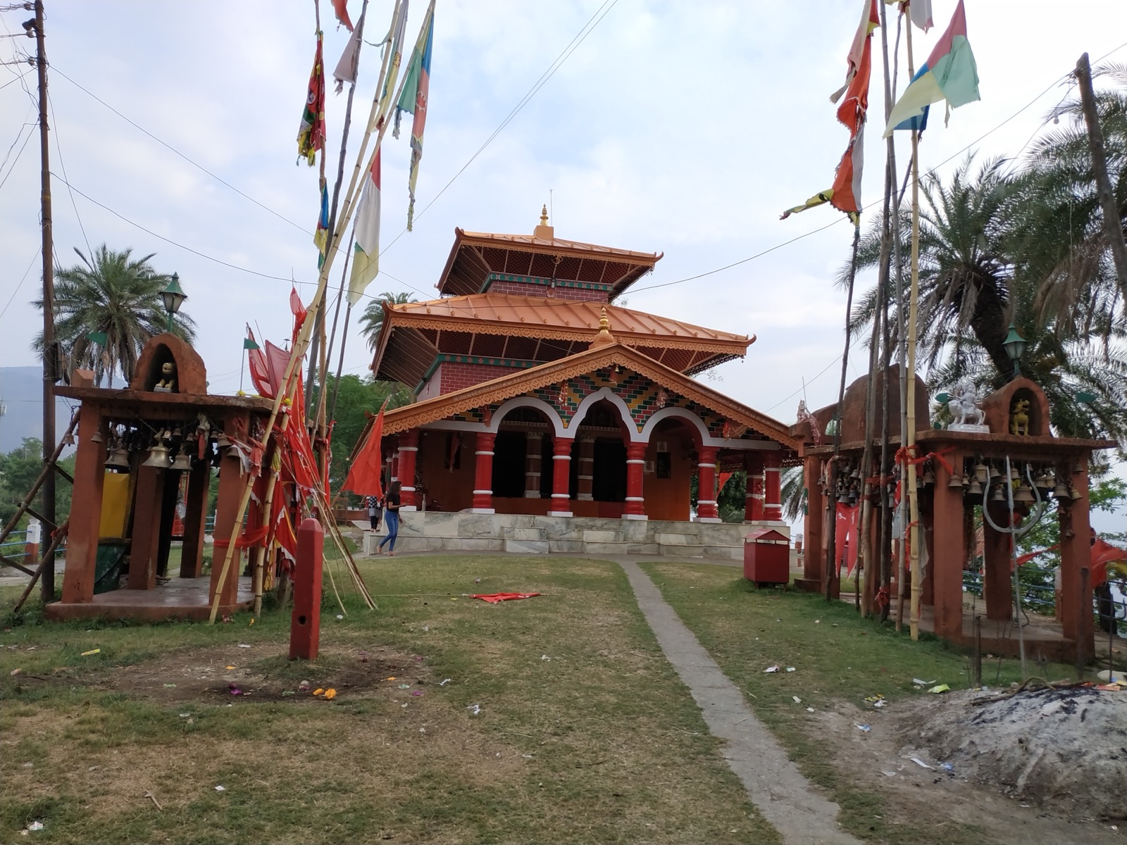
Tripura Sundari is a pagoda-style temple4. Many worshippers travel from around the world to visit the temple at Ishori Gangadham4. The archaeological site there has stone inscriptions and utensils4.
Bhatana Mahadev Temple is an ancient Hindu temple4. At the Niglasaini temple, one of Bhagwati’s seven sister temples, hundreds of bulls and goats are sacrificed to the goddess during the festival4.
The Gwallek Kedar sacred forest lies wholly within Baitadi and is considered the most important of the four Kedars along the Indo-Nepal border1.
Fruits such as mandarins and oranges are grown in Baitadi and exported to Bhimdatta and Dhangadhi1. Volleyball and cricket are very popular, and Baitadi has produced eminent national cricket players1.
Population
The 2021 census report counted 242,157 people in Baitadi3. It gives 113,864 male and 128,293 female3. Baitadi is the third most populous district of Sudurpashchim Province, behind Kailali, the largest at 904,666, and Kanchanpur3. See Kailali and Kanchanpur.
The 2011 national report recorded 250,898 people at a density of 165 per km26. Wikipedia gives the same 2011 and 2021 totals1,3,6. Chhetris make up 53% of the population and Khas Dalits 22%1. Khas people make up nearly the entire population1.
History
Baitadi was initially part of the Great Katyuri Kingdom4. During the Khas kingdom it was one of three major centres1. It was part of the Kumaon Kingdom until the Gorkha invasion of Kumaon in 17911. The district was then merged into Doti District until 18851. Darchula separated from Baitadi in 19621. See Doti and Darchula.
Permits and park fees
Khaptad National Park stretches over Bajhang, Bajura, Achham and Doti, not over Baitadi5. It was established in 1984 on the advice of Khaptad Baba5. The Nepal Tourism Board’s park entry-fee page lists the entry fee per person per entry9:
| Visitor | Khaptad National Park entry | Seen |
|---|---|---|
| Nepali | NPR 100 per person per entry | October 20269 |
| SAARC national | NPR 1,500 per person per entry | October 20269 |
| Foreigner | NPR 3,000 per person per entry | October 20269 |
A park entry permit must be obtained to enter protected areas, and entrance fees must be paid9.
The park itself has moorland, steep slopes and streams, with 567 floral species5. More is on Khaptad National Park.
Read next
Dadeldhura: Amargadhi, the Bhimdatta Highway and Ugratara
Dadeldhura district guide: Amargadhi headquarters, the Seti and Bhimdatta Highway links, altitude and climate, municipalities and Ugratara temple.
Permits and feesKhaptad National Park: entry fee, how to reach it and when to go
Khaptad National Park guide: the entry fee for Nepalis, SAARC nationals and foreigners, Silgadhi access, the Triveni and Sahasra Linga sites, season and safety.
Getting thereFlights to Dhangadhi: Kathmandu schedules, flight time and airport facts
Kathmandu to Dhangadhi flights: Buddha Air and Shree Airlines schedules as seen October 2026, flight time, fares on record, and Dhangadhi Airport facts.
Questions travellers ask
In which province is Baitadi District located?
Baitadi is in Sudurpashchim Province, one of Nepal's seventy-seven districts1. It lies in the farthest west of Nepal and touches India at Jhulaghat1.
How many municipalities are in Baitadi district?
Baitadi has four municipalities, Dasharathchand, Patan, Purchaudi and Melauli7. It also has six rural municipalities, ten local units in all7,1.
What is the population of Baitadi district?
The 2021 census recorded 242,157 people, 113,864 male and 128,293 female3. The [2011 national report](http://cbs.gov.np/wp-content/uploads/2012/11/National%20Report.pdf) recorded 250,8986. Baitadi is the third most populous of Sudurpashchim's nine districts3.
What is the capital of Baitadi district?
Dasharathchand is a municipality and the district headquarters of Baitadi2.
Sources
- Baitadi District - Wikipedia · Wikipedia · en.wikipedia.org · checked 20 October 2026
- Dasharathchand - Wikipedia · Wikipedia · en.wikipedia.org · checked 20 October 2026
- Sudurpaschim Province census report, National Population and Housing Census 2021 · Central Bureau of Statistics, Nepal · censusnepal.cbs.gov.np · checked 20 October 2026
- Baitadi District Sudurpaschim Province - Hop Nepal · Hop Nepal · hopnepal.com · checked 20 October 2026
- Khaptad National Park - Wikipedia · Wikipedia · en.wikipedia.org · checked 20 October 2026
- National Report, Population Census 2011 (Wayback) · Central Bureau of Statistics, Nepal · cbs.gov.np · checked 20 October 2026
- District Coordination Committee Baitadi (Wayback) · DCC Baitadi, Sudurpashchim Province · ddcbaitadi.gov.np · checked 20 October 2026
- Dhangadhi Airport - Wikipedia · Wikipedia · en.wikipedia.org · checked 20 October 2026
- Park Entry Fees in Nepal · Nepal Tourism Board · ntb.gov.np · checked 20 October 2026
Image credits (1)
- Nirajan pant / Wikimedia Commons · CC BY-SA 4.0 · source

Fees, fares and road conditions change: each note shows the date it was checked. How we check facts · Report an error.